Science High School Reviewer Earth Science: Earth and Its Resources
Disclosure: This post may contain affiliate links. When you buy through links on my site, I may earn a small commission. Thank you for your support.
Viewed from space, Earth’s land might seem
flat. From close up, you can see many natural
features on Earth’s surface. These features are
called landforms.
Tallest and Flattest
The tallest and most visible landforms are
mountains. Most rise steeply to a peak at the
top. Others have a gentle slope. Some are
volcanoes formed by melted rock.
A plain is the flattest kind of landform. Plains
are vast areas of land without hills or mountains.
Landforms Shaped by Water
Flowing water can shape the land. Streams
and rivers can cut small channels or larger
gullies where they flow. Strong flows can create
deep valleys. In some places, rivers form narrow,
V-shaped valleys called canyons. The Grand
Canyon is more than one kilometer deep!
Waves wear away land, too. Waves can make
a beach flat and smooth or sharp and rocky.
Landforms Shaped by Wind
Gusts of wind can pile sand into
large mounds in deserts and on
beaches. These mounds are called
sand dunes. Wind can also
combine with water to make
mountains steeper and
valleys deeper.
What does it look like
where water meets land?
Water always flows downhill.
What happens when it gets to the
bottom of a landform?
River Deltas
As the land gets flatter, the flow
of a river slows. If the river empties
into an ocean, the water moves even
slower. It drops off bits of sand and
soil it carried. The bits form a delta—
a landform shaped like a triangle.
Drainage Basins
Some rivers empty into channels.
A channel that carries water is called
a drainage (DRAY-nihj). A drainage
basin is the area of land drained by
flowing water. Much of central North
America, for example, is a drainage
basin for the Mississippi River.
Continental Shelves
It’s a sunny day at the beach. You
want to swim with your friends.
You move farther and farther from
shore, but the water is still too
shallow. Where are you? You are on
a continental shelf. The continental
shelf is the land connecting shore to
sea. It can stretch seaward for miles.
Beyond the Continent
Beyond the continental shelf is an
area of land called the continental
slope. This land is the steeper part
of the continent that slopes down
toward the ocean floor. Underwater
canyons can form on the slope.
At the base of the slope lies the
continental rise. The rise connects
the continent and ocean floor.
Most of the ocean floor is
flat and without features. Long
mountain ranges, though, stretch
through the middles of some oceans.
These are ocean ridges. The ocean
floor is spotted with undersea
volcanoes, too. Deep trenches can
cut far into the ocean floor.
The Interiors of the Earth
The Earth’s layers
Crust Solid rock that
makes up Earth’s
outermost layer. It is
brittle and can crack
easily. Earth’s landforms
and underwater features
are found on the crust.
Mantle Layer of rock
below the crust. It is
solid, but some of the
rock can move or
change shape at high
pressures and
temperatures.
Outer Core Liquid
layer below the
mantle. It is made
mostly of melted iron.
Inner Core Sphere of
solid material at Earth’s
center. It is the hottest
part of Earth. It is
probably made of iron.
How does Earth’s crust move?
You have learned that Earth is made up of
layers. The crust is the thin outer layer. The
mantle lies beneath the crust.
Plates
Earth’s surface is broken into several huge
plates of rock. Plates are made of crust. The crust
is solid. The upper mantle can flow. When the
mantle flows, Earth’s plates move.
Earth’s plates move about as slowly as your
fingernails grow. The edges of plates are where
changes to the crust happen. You cannot see or
feel most of the changes. Others you cannot miss!
Faults
Some plates slide past each other
from side to side. The place where
they rub is called a fault. A fault is a
long, narrow crack in the crust.
A plate on one side of a fault
can slide up while the other slips
down. Rising plates can form faultblock
mountains. If the lifting is
spread over a wide area, a plateau
(pla•TOH) may form. A plateau is a
high landform with a flat top.
Folds
Some plates meet at the edges of
continents. If the land scrunches up
between them, a fold forms. A fold
is a bend in the rock layers.
If the land keeps scrunching,
a fold becomes a mountain. A
mountain is a tall landform that rises
to a peak. As time passes, wind and
rain can break off bits and pieces.
What causes
earthquakes?
An earthquake is a sudden
shaking of Earth’s crust. It is
caused by plates moving along a
fault. When the plates slide against
each other, energy builds up in the
rock. Rocks may store this energy
for many years in Earth’s crust.
Then suddenly, they break apart!
Earthquakes are common in places
with active faults, like parts of
Alaska and California.
How Earthquakes Travel
An earthquake begins below
the ground. The energy released by
a sudden plate motion shakes the
crust. Vibrations, or waves, move
through the crust in all directions.
Did you ever drop a pebble in
water? The waves of an earthquake
travel like the ripples of water. As
they move away from the center of
the earthquake, the waves weaken.
Even so, you may feel them at the
surface hundreds of miles away!
Earthquakes in the Ocean
Some earthquakes strike below
the ocean. If an earthquake is strong
enough, it can cause the ocean crust
to lift suddenly. When this happens,
look out! A giant ocean wave, or
tsunami (soo•NAH•mee), might hit
the shore. Tsunamis cause the most
damage along coastlines. They can
destroy everything in their path.
How do scientists study
earthquakes?
Any movement can cause a
vibration. Seismic waves are the
vibrations caused by earthquakes.
When an earthquake strikes,
seismic waves travel out from
the source in all directions. The
waves move at different speeds.
Some of the waves travel along or
near Earth’s surface. Others travel
through Earth’s interior.
Measuring Seismic Waves
Scientists measure seismic
waves with an instrument called
a seismograph (SIZE•muh•graf). A
seismograph detects and records
earthquakes. It shows seismic
waves as curvy lines along a
graph. The lines show how much
the ground shakes. The stronger
the quake, the steeper the lines.
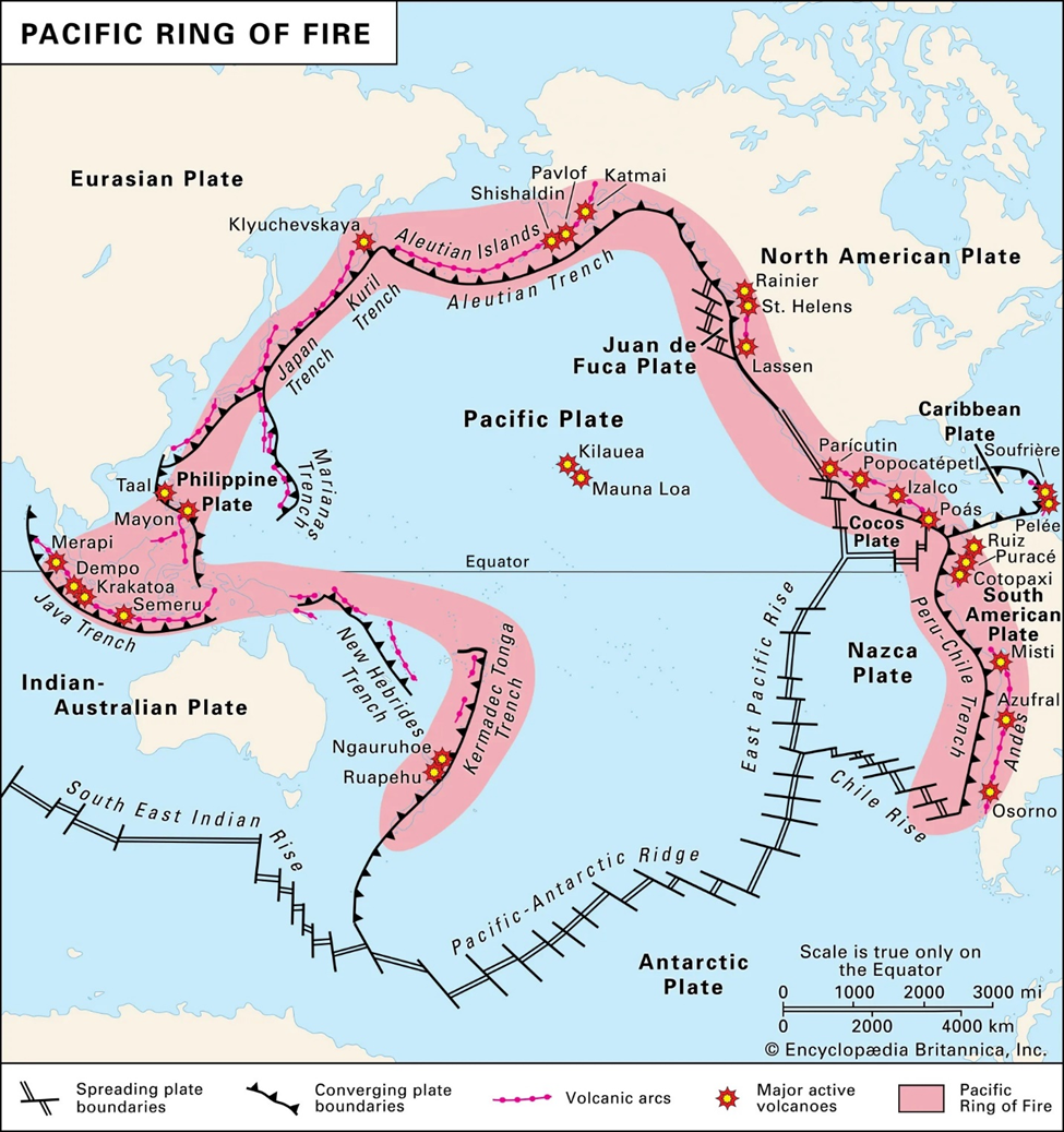
What is a volcano?
A volcano is a mountain that
builds up around an opening in
Earth’s crust. Sometimes a volcano
will force materials from Earth’s
interior out of its opening. Scientists
call this event an eruption.
A volcanic eruption can send out
melted rock, gases, ash, or small
rocks into the air. Melted rock is
called magma. Once magma reaches
Earth’s surface, it is called lava. By
erupting often, a volcano can build a
large mountain. Each eruption adds
a layer of lava and ash. The lava and
ash cool and harden into rock.
Some volcanoes rest quietly
for many years until they erupt
suddenly. Others erupted often in
the past, but will never erupt again.
Where Volcanoes Form
Most volcanoes occur at the
edges of plates. When two plates
meet up, one can sink below the
other. As it sinks, the plate gets
hotter. The rock melts into magma.
The magma rises and forms a volcano.
Volcanoes also form where
Earth’s plates move apart. The space
between the moving plates allows
magma to rise to the surface.
Some volcanoes form far away from
plate edges. These hot spots are places
where Earth’s crust is very thin. Magma
can easily break through to the surface.
The islands of Hawaii formed over
a hot spot in the Pacific Ocean. The
islands are the tops of huge volcanoes
that rose from the ocean floor.
What are the features of the
ocean floor?
Although waves move over the surface of the ocean, the
ocean’s surface is mostly flat. However, if you could travel
beneath the ocean’s surface, you would find features on the
ocean floor that look like mountains and valleys.
An ocean basin is a large underwater area between continents.
Along the coast of a continent, the ocean floor is called the
continental shelf. Here the ocean floor is covered by shallow
water and gradually slopes down. A continental shelf ends at a
point where a sharp slope begins. This sharp slope is called the
continental slope.
A submarine canyon is a steep-sided valley in a continental
slope. Submarine canyons often are found near the mouths of
large rivers. At the end of a continental slope is another gradual
downward slope called a continental rise.
The abyssal plain (uh•BIS•uhl playn) is a wide, flat area of
ocean floor. Abyssal plains cover about 40% of the ocean floor.
How are Earth’s features mapped?
Earth’s surface is uneven. Hills rise in one place, while
valleys dip in another place. While some places are higher or
lower than other places, maps of the surface are flat. How
can a flat map show an uneven surface?
Relief Maps
A surveyor is a person who takes measurements of land.
As the first step in making a map, a surveyor measures the
elevation in a specific location. Elevation is the height of
land above sea level. The surveyor may leave an object as a
benchmark, or permanent reference point, for that elevation.
Mapmakers then use the surveyor’s measurements to
show changes in elevation on a map. One way to do this is
to draw a shaded picture of the land. The shading makes a
map look as if it has three dimensions: length, width, and
height. The map, of course, really has only two dimensions:
length and width. A map that uses shading to show
elevations is called a relief map.
Topographical Maps
A map that uses lines to show
elevation is called a topographical map
(top•uh•GRAF•i•kuhl). Each contour
line represents a different elevation. A
number on the line gives the elevation.
The number is usually in units of
meters or feet.
In addition to elevation, contour
lines can tell you how steep or gradual
a slope is. Contour lines that are
close together mean that elevation is changing rapidly and the slope of the
land is very steep. Contour lines that
are far apart mean that elevation is
changing gradually.
Where is water on Earth?
The hydrosphere (HIGH•druh•sfeer) is
the part of Earth that contains water. Water covers
about 75 percent of Earth’s surface. It exists in many
forms and in many places in the hydrosphere. Water
can be found as a solid, in the form of ice or snow;
as a liquid, in oceans, lakes, and rivers; and in the
atmosphere, as water vapor or water droplets.
Earth’s water exists in two basic
forms: salt water and fresh water.
More than 95 percent of the water
on Earth is salt water, or water that
has salts dissolved in it. Ocean water
contains salts such as sodium chloride
and magnesium chloride. Scientists use
the term salinity to describe how much
salt is dissolved in water.
Fresh water contains little or no salt.
It comes from sources such as rivers,
lakes, and also from rainfall. Most
of Earth’s fresh water exists as ice.
Glaciers are large sheets of ice that
slowly move. Valley glaciers form
at high elevations, in areas such as
mountains. Continental glaciers cover
large parts of the polar regions.
Earth’s landforms
A landform is a physical feature on Earth’s surface.
Each landform has specific characteristics and each
landform forms in a different way.
Earth’s Land Features
A mountain is a landform that rises high above the ground.
A hill is lower and rounder than a mountain.
A valley is low land between hills or mountains.
A canyon is a deep valley with high, steep sides.
A cliff is a high, steep section of rock or soil.
A plain is a wide, flat area.
A plateau is flat land that is higher than the land around it.
A desert is an area with very little precipitation.
A beach is the land along the edge of a body of water.
A dune is a mound or ridge of sand.
Earth’s Water Features
An ocean is a large body of salt water.
A coast is where a body of water meets land.
A tributary is a small river or stream.
A river is a natural body of moving water.
A waterfall is a natural stream of water falling from a high place.
A lake is a body of water surrounded by land.
An estuary is where river water and ocean water meet.
A delta is the mass of land that forms at the mouth of a river.
An inlet is a narrow body of water off of a larger body of water.
The Earth’s Moving Continents
Are the continents moving?
In 1915 Alfred Wegener, a German scientist,
published a book proposing that the continents had
been connected as a single body of land earlier in
Earth’s history. Wegener gave evidence for his idea.
He showed that some of the continents fit together
like pieces of a jigsaw puzzle. He noted places in
which different continents had fossils of the same
plants and animals and matching rocks, glaciers, or
mountain ranges. He also noted that Antarctica had
fossils of species that were most likely tropical. This
suggested that Antarctica had been located near the
equator at one time.
Wegener concluded that all the continents had
once been part of a single “supercontinent.” He called
this landmass Pangaea (pan•JEE•uh). He suggested
that Pangaea later split apart and that the continents
then “drifted” to their present positions. Wegener’s
concept became known as continental drift.
Plate tectonics
Scientists developed a model called plate tectonics to explain how the
continents and the ocean floor could
move. According to this model, Earth’s
surface is broken into pieces, or plates.
The plates move over the hot, fluid
rock, or magma, in the mantle.
Uneven heating in the mantle
produces slow-moving currents of
plasticlike, fluid rock. The cooler, rigid
rock of the lithosphere rests on top of
this fluid rock. The slow movements
in the fluid part of the mantle drag the
lithosphere and its plates sideways. As
the lithosphere moves, so do the ocean
floor and continental plates.
How do oceans change size?
The processes that move continents also help form new crust on
the ocean floor. As some crustal plates move apart, magma enters the
cracks and flows outward. The magma cools, hardens, and builds up
into parallel ridges, or raised structures, on the ocean floor. The new
rock exerts a sideways force called compression. Magma continues to
flow between the plates, forcing them farther apart. This process
is called seafloor spreading.
Seafloor spreading explains how plates move apart and new crust
forms. At the Mid-Atlantic Ridge in the Atlantic Ocean, new seafloor
crust is formed at the rate of about 3 centimeters (1 inch) per year.
Plate boundaries
What happens at
plate boundaries?
Plates can move in three ways.
They can move apart from each other,
they can collide, and they can slide past
each other.
Locations where plates move
apart are called divergent boundaries.
Seafloor spreading occurs at divergent
boundaries. Divergent boundaries also
occur on land. Iceland is located on a
divergent boundary at the northern end
of the Mid-Atlantic Ridge. The Great
Rift Valley in Africa is also a divergent
boundary. There, the continent of
Africa is splitting. The split may one
day form a new ocean. Some divergent
boundaries are less visible, occurring
within a continental plate.
Locations where plates collide
are convergent boundaries. If both
colliding plates include continents, the
pressure lifts and crumples the plates,
forming mountains. Earthquakes
and volcanic activity can occur at
convergent boundaries.
Sometimes one colliding plate
carries part of an ocean floor, and
the other carries part of a continent.
Then the oceanic plate slides under the
continental plate in a process called
subduction. The edge of the oceanic
plate is pushed down into the mantle
and melts. Some of the magma beneath
rises through cracks between the
plates. At the surface, a volcano forms.
When plates move toward each
other on the ocean floor, one plate
sinks under the other. This movement
forms an ocean trench.
Sliding Plates
Some plates simply slide past
each other. The boundary between
these plates is a transform boundary.
Earthquakes can occur along these
boundaries as strain on the rock
builds up and then is quickly released.
Rock along these boundaries shatters
and breaks. Eventually, this rock
may pile up and form narrow ridges
and valleys.
Where are the plates?
Earth’s crust has seven major
tectonic plates. Some of the plates are
diverging, or moving apart. Others are
converging, or pushing together.
Mid-ocean ridges occur along
diverging plates. The Mid-Atlantic
Ridge is located where the South
American Plate is moving away from
the African Plate.
Convergent boundaries can be
found at many large mountain chains.
The Himalayas are located where
the Indian Plate is colliding with the
Eurasian Plate. The Alps are located
where the African Plate is colliding
with the Eurasian Plate.
Most transform boundaries are
located on the ocean floor. On land the
most noticeable transform boundary
is the San Andreas Fault between the
North American Plate and the Pacific
Plate. This fault is the site of many
powerful earthquakes.
Philippines – Pacific Ring of Fire